|
|
|

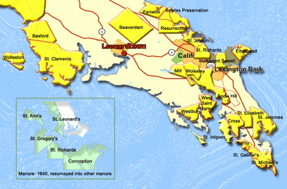 Manor Map from St Mary’s Families. On this site you can click onto the various manors to obtain information about each one. Also see their map showing the location of Harvey Hundred and their list and map of Harvey Hundred landowners according to a 1705 plat. It looks like relevant lands were owned by Thomas Bankes, Richard Bayley, and Andrew Robinson. Manor Map from St Mary’s Families. On this site you can click onto the various manors to obtain information about each one. Also see their map showing the location of Harvey Hundred and their list and map of Harvey Hundred landowners according to a 1705 plat. It looks like relevant lands were owned by Thomas Bankes, Richard Bayley, and Andrew Robinson. |
“,,, Nicholas Harvey, who came into the Province in 1634 with Leonard Calvert [on the Ark & Dove] .... was granted a patent for land on the Patuxent River opposite PointPatience, called "St Joseph's Manor." Nicholas Harvey was a member of the First Assembly held in the Colony; he was also one of the first to receive a military commission, having; received a commission from Leonard Calvert on the third of January, 1639, to raise a company to go against the nationcalled the Maquantequants, a tribe of Indians who were committing sundry insolences upon the English inhabitants. Nicholas Harvey died in 1641 [1647?], leaving a wife and one daughter, Frances, who married Capt. George Beckwith. Augustine Herman, in his map made in 1670, shows the position of a town called Harveytown named for this Nicholas Harvey, which was probably the second town laid out in the province. ”
Harvey Town was one of the first settlements in Maryland. It is located inthe area of Myrtle Point Park but we do not have defining marks for it. Itis something we are working on. The area has been surveyed by archeologistDr. Julia King. --Dudley Lindsley Friends of Myrtle Point
Myrtle Point Funding Approval Ends Years Of Speculation, Leads To Creation Of Waterfront Park For St. Mary's
Annapolis, MD (January 8, 1997)--St. Mary's County officialscan begin planning for an historical waterfront recreationalfacility thanks to Board of Public Works approval of more than$1.8 million to purchase a segment of Myrtle Point....."Myrtle Point is one of the most significant undevelopedtracts along the Patuxent River," Governor Glendening said. "Richin history and natural resources, public ownership of this areawill provide for public access to the river, creation of a park,and other recreational opportunities where none currently exist."....The peninsula lies on the western shore of the Patuxent between Greenwell State Park and the Thomas Johnson Bridge. The area contains numerous historic sites, some dating back more than 9,000 years. Chiggrefeld and Cuckold Manor, two 17th centuryresidences on the point, are associated with Harveytown, one ofthe first settlements in the state. And at least nine of 37archeological sites identified in a 1986-1988 study of the localewere determined to eligible for the National Register of HistoricPlaces. Posted January 10, 1997
Notice.SUMMARYNotice is hereby given thatthe property known as Hanover Run/Myrtle Point, located in California, St. Mary’s County, Maryland, is affected by Section 10 of the Coastal Barrier Improvement Act of 1990....Copies of detailed descriptions of this property, including maps, can be obtained from or are available for inspection by contacting the following person: Mr. James C. Kimball, RTC/FDIC Atlanta Field Office, 245 Peachtree Center Avenue, NE, Marquis One Tower, 10th Floor, Atlanta, GA 30303, (404) 225Ð5707; Fax (404) 230Ð8159.SUPPLEMENTARY INFORMATIONThe Hanover Run/Myrtle Point property is located on Patuxent Boulevard north of Maryland Route 4 and south of Mill Creek and the Patuxent River, St. MaryÕs County, Maryland. The site consists of approximately 502.11 acres of undeveloped land that is almost completely forested. This property contains wetlands, salt ponds, archaeological resources of early native American culture, and two 17th century plantations near the colonial port of Harveytown. The northern and eastern portions of the site which border the Patuxent River, Sam Abel Cove, Mill Creek, and Little Kingston Creek are situated within undeveloped floodplains. The Hanover Run/>Myrtle Point property is adjacent to ClarkÕs Landing which is managed by the Department of Recreation and Parks of St. MaryÕs County for recreational purposes. [Clarks Wharf: (landing) in St. Mary's County;on west shore of Cuckold Creek, (3 3/4) mileseast of Hollywood; elev. 5.(N. 38¡20' W. 76¡30') LEO -- Gazetteer of Maryland, 1941]This property is covered property within the meaning of Section 10 of the Coastal Barrier Improvement Act of 1990, Public Law 101Ð591 (12U.S.C. 1441aÐ3). This tour was created befor Myrtle Point was purchased as a park, but Myrtle Point is within the territory covered by the tour, within the final “sidetrack” into St. Mary’s County from SolomanÕs Island. Most of this tour follows theMD 2/4 corridor through a land of tobacco farms and waterfront communities.....Calvert County has a long history. The first permanent settlement was on St. Leonard Creek around 1640 and in 1658, the county was created and given Lord BaltimoreÕs family name. You will start your tour, however, in Charles County by turning off MD 231 onto Benedict Road. This will take you to Benedict, where you can enjoy the view of the river and Calvert County on the opposite shore as you sample local seafood and the famous Southern Maryland cooking at one of several Patuxent River-front restaurants. Benedict was an important 18th-century shipping center and later, was where the British landed during the war of 1812 and marched off to Bladensburg and an attack on Washington, D.C. Continue on MD 231 across the Patuxent River into Calvert County. On the right is a public boat ramp on Hallowing PointPrince Frederick, which was burned in 1814 by British raiders on their way to Washington. Cross MD 2/4, and turn right on Main Street, which is MD 765, or Old SolomonÕs Island Road. The handsome white portico of the present brick Calvert County Courthouse, built in 1914, shows through trees that shaded the original courthouse. Where Main Street meets MD 2/4, turn left and head south. Sidetrack: Two miles west of MD 2/4, turn right on MD 506 to visit Battle Creek Cypress Swamp, a Bald Cypress reserve and amphibian sanctuary that is a NationalNatural Landmark. It is one of the last remaining stands of Bald Cypress in Maryland and the most northerly growth in the country.Continue south on MD 2/4.Sidetrack: Turn left on MD 264 to Broome’s Island, Sidetrack: From MD 264, turn south on MD 265, or Mackall Road, which takes you past tobacco farms to the 544-acre Jefferson Patterson Park and Museum, home to the Maryland Archaeological Conservation Laboratory and the Academy of Natural Sciences Estuarine Research Center. The museum traces human habitation of the area for the past 12,000 years. Mackall Road ends at an old steamboat landing. Follow MD 2/4 south to MD 264 and turn left on St. Leonard Road, which becomes MD 765. Follow this route to St. Leonard, a historic crossroads town and modern-day antique center. Continue on MD 765, and turn left on MD 2/4, which takes you south through the narrowest part of the Calvert County peninsula. On the left is the entrance to Flag Ponds Nature Park, a 327-acre bay-front nature preserve, which offers picnicking, crabbing, fishing, hiking, and swimming. The wooded bluffs of Calvert Cliffs, freshwater ponds, and small beaches provide habitats within the park for a large diversity of wildlife. Return to MD 2/4, and drive south to Calvert Cliffs Nuclear Power Plant, stopping for information on plant tours at the VisitorÕs Center. The adjacent tobacco barn serves as a museum housing a display of fossils found at Calvert Cliffs, artifacts relating to Indian life in the area, and exhibits ranging from tobacco culture to technology. Next to the museum, the ruins of an 18th-century house are interpreted to tell of early life in this area. Continue south on MD 2/4, and turn left on MD 765, or H. G. Trueman Road, into Lusby. Visit Middleham Chapel, whose congregation was founded in 1684 and has been active ever since. The chapel is located on the left in a grove of shellbark hickory trees. Follow MD 765 into Solomons. Named for Isaac Solomon, who operated oyster packing plants, the village with its deep, protected harbor became a shipbuilding center to supply the islandÕs oyster fleet and a variety of boats to work the Bay. The famed “bugeye” sailing crafts were built here in the 19th-century. During the War of 1812, Commodore Joshua Barney’s flotilla made a disastrous attempt to deter the superior British naval force on its way to attack Washington, D.C. Relic from the USS Scorpion, one of Josua Barney’s fleet of barges, scuttled in the Patuxent RiverMaryland Scenic Byways: Southern Region
Calvert Maritime Tour

Length: 25 miles Driving Time: 1 hour :
 which is not really an island but a narrow peninsula formed by the Patuxent River and Island Creek. On the way, about a 1/2 mile south of MD 2/4, visit Christ Church (circa 1772). One of MarylandÕs earliest colonial parishes, the church serves Calvert CountyÕs longest continuously active congregation. The church grounds are the site of an annual jousting tournament held here for over 130 years. Adjacent to Christ Church is the BroomeÕs Island One-Room School House, which operated from 1830 to 1932 and is now a museum that tells the story of the days when a single teacher usually taught seven grades, and the children walked as far as three miles to school. The southern tip of this peninsula offers excellent views up and down the river and Island Creek. Here, the landmark Warren Denton Oyster Company, established in 1927, is the only oyster packing plant still operating in Calvert County.
 Continue farther south to Calvert Cliffs State Park, a 1,600-acre park where you can see sections of the exposed cliffs formed over 15 million years ago and first described in 1608 by Captain John Smith. Bluffs as high as 150-feet in some places follow the shore for 30 miles from Chesapeake Beach to Cove Point. The cliffs are world-famous for their geological formations and exposed deposits of over 600 fossil species from the Miocene period, 7 to 26 million years ago. You can take a two mile hike to the beach to hunt for sharks teeth and other fossils and enjoy the view of the cliffs and Bay. The parkÕs 13 miles of hiking trails, which take you through a diverse state-protected landscape of forest, marsh, beach, wetland, and ponds, offer opportunities for birding, fishing, and other outdoor experiences. Back in your car, continue south on MD 765.Sidetrack: Turn left on Dowell Road at Solomons Firehouse to visit Anmarie Garden, a 30-acre parcel of land being developed as a world-class sculpture garden. Here, contemporary sculptures and cultural programs offer a new way of appreciating the beauty of surrounding plants and wildlife.
Follow Solomons Island Road to the southern tip of the island for a spectacular view of the riverÕs mouth and the Bay beyond. On the point is the Chesapeake Biological Laboratory, founded in 1928 as part of the University of Maryland Center for Environmental Science. The lab has grown into a major center for estuarine research. Although the byway ends here, you may consider driving farther south on MD 4, where you can pick up the Religious Freedom Scenic Byway in Leonardtown.
Sidetrack: Follow MD 4 south, and turn right on MD 235 and then, right again on MD 245, or Sotterley Road. This takes you to Sotterley Mansion and Greenwell State Park in St. MaryÕs County. Continue on MD 245 for about six miles, and turn right on tree-lined Sotterley Lane, which takes you to Sotterley on the Patuxent River. The oldest section of Sotterley was built in 1710 by James Bowles, a merchant, and then it was enlarged by George Plater III, who named Sotterley for the Plater family home in England. Today, the mansion is the only surviving Tidewater plantation house in Maryland that is open to the public. As you head back on Sotterley Road, turn left on Steer Horn Neck Road to Greenwell State Park, a 576-acre tract of land on the Patuxent River. At the center of the park, which is named for the landÕs original owner, Philip Greenwell, is the Rosedale Manor House. In addition to trails for hiking, the park offers areas for fishing, picnicking, hunting, and canoeing or kayaking. Please note, however, that the swimming beaches have no life guards.
- Sotterley Mansion House Exterior, Smithsonian Magazine
- Most Endangered Places in America: Sotterly Plantation by Smithsonian Magazine (1996)
- MCPS Sotterly Plantation Social Studies Field Trip
- Afternoon Walk A Painting of the Sotterley grounds
- Patuxent from Sotterley A painting from the Sotterley grounds
- Southern Maryland .Info Resurrection/Sotterley Manor
- ÊSotterley was a tobacco plantation built by James Bowles in 1717.Ê It was originally called Resurrection Manor.Ê The plantation fell into the hands of the Plater Family through marriage.Ê They renamed it Sotterley after their ancestral home in Suffolk, England.Ê Sotterley was a major port of entry in the 1700's with its own customhouse. Sotterley Plantation was inherited by Mabel Satterlee Ingalls in 1947, who set up a historic trust and opened the Plantation to the public in 1961. Visitors can tour the manor house and gardens, view the 11 outbuildings, which include a school, smokehouse, tobacco barn, and slave cabin.
- Painting of Sotterly garden
- Mentions Hon. John Hanson Briscoe.
- Painting of Sotterley Bedroom
Sotterley Plantation Site
- Sotterley History
- James Bowles (?-1727) Builder of Sotterley
Photo Tour of Sotterley Manor by Chesapeake Bay Gateways Network
Grape Arbor at Sotterly Print by Corn Crib Studio and Sotterley Rose Arbor
Old photo of Sotterley from the Maryland State Historical Society Southern Maryland Collection
ÊThis tour was developed by the Maryland State Department of Transportation prior to the acquisition by the State of Myrtle Point. Myrtle Points location in the context of this tour can be seen on this map: Aerial Photo from near Myrtle Point looking at Solomans, the Bridge, and Pax River Runway
The Maryland Calendar of Wills, Volume IHarvy, Nicholas, Patuxent River -- Aug., 1644 28th June 1647 Dau. Frances, sole legatee Test: William Wheatley, Henry Spink. 1. 11. Editors: One Nicholas Hervey was transported to Maryland in 1633-4 (Patents 1:20, 37, Skordas), and one Nicholas Harvey [sic] was transported to Maryland by 1634 (Patents ABH:66, and 1:38, ibid.). One Nicholas Hervey immigrated to Maryland in 1641 with wife (unnamed), daughter Frances and others (Patents 1:129-30, ibid.); and one Nicholas Harvey immigrated in 1641 with wife (unnamed) and daughter, Frances and others (Patents ABH:102, 103, Skordas and Gibb). One Nicholas Hervey received a special warrant from Lord Baltimore dated 8 Sep 1641, London, for 1,000 acres conditioned on his emigrating with his wife and five others. (Patents ABH:103, ibid.). Jane, widow of Nicholas Harvey (the same?) had been transported to Maryland by 1653, and by 1664 was the wife of Thos. Greene (Patents CC:53-4, Skordas)—except that elsewhere in this volume, Skordas indicates that Jane, widow of Nicholas Harvey, married Thomas Greene by 1653 (Patents 7:62, ibid.). By 1658, Nicholas' daughter Frances had married George Beckwith, to whom the land of Nicholas Harvey, deceased, was transferred as "husband of Francis, daughter and heir." (QO:268) (Skordas & Gibb) Nicholas Harvey (or Hervey) is also claimed as having been a passenger on the The Ark and the Dove, and a Nicholas Hervey appears in the records of the 1637 Freeman's Assembly. See also 165 deed of trust and notes for Thomas Greene. Liber A. 29o Sept. [1549] It is agreed betweene Mr Cuthbert ffenwick theAdministrator of Nichas Harvey deceased and John dandy thatone Cowe three yeares and a half old another of two yearesand a half old and a heifer of a yeare and a half old wch wereformerly part of the Estate of the said Nichas Harvey togetherwith theire Increase male and female shall by theire Joint guiftbee and remayne to the sole and proper vse of ffrancis Harveythe daughter of the said Nichas Harvey her heires and Assignesfor ever wch guift they the said Mr Cuthbert ffenwick and John dandy doe hereby warrant against all iust claymes wchcattell the said Mr ffenwick doth hereby deliver to the saidJohn dandy to bee by him kept and prserved to the vse beforemenconed Witnes theire hands this 20th of September 1649Itn Testor Tho: Hatton Cuth: ffenwick Cox, Richard (nunc.) -- -- --; 7th Sept., 1647 Anthony Rawlings, admr. and sole legatee. Test: Ralph Crouch. 1.11 Editors: Richard Cox was transported to Maryland before 1643, with service by 1643 or 1644 (Patents AB&H:15, Gibb) |
BECKWITH Marriages extrapolated from documents
St. Mary’s Career File InformationNuthall, Elizabeth Beckwith (?-?) Husband: Elias Nuthall. Parents: George Beckwith (SM#326) and Frances, daughter of Nicholas Harvey. Siblings: Mary, Barbara, Margaret, Charles. |
