
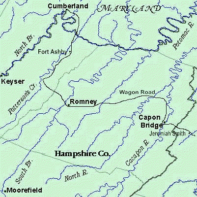
Source of Map:Smoot Family,
Source of Text: Hampshire History
Sources of Information for Hampshire County
Hampshire County Map Room
|
|
|
This Indenture made the sixteenth day of November in the year of our Lord one thousand seven hundred and eighty seven between Christiana Neff, widow and relict of Henry Neff late of the County of Hampshire now deceased and Adam Neff, eldest son of the said Henry Neff, Thomas Barton Smoot and Catherine his wife, late Catherine Neff and Esther Neff daughters of the said Henry Neff of the one part and Sylvester Welch of the said county of the other part. ... said Henry Neff in his lifetime being seized in fee simple and possessed of a certain tract of land on the southwest side of Patterson’s Creek and run called Ramsey’s Run, a drain of the said creek adjoining the Manor of the said County of Hampshire bounded as follows, to wit: Beginning at... corner to Peter Beaver, then with his line South 23° 15me West... to ... brow of a hill ... near the said Beaver’s fence, thence extending from his line N 66° 45me W... to a black oak on a level, thence S 23° 15me W fifty poles to a white oak and hickory standing on the east side of the wagon road from Fort Pleasant,† then S 66° 45me E ....... to the line of the said Beaver by a large white oak on a descent near his fence, then with his line S 23° 15me W at about 116 poles, crossed the road from Fort Pleasant one hundred and eighty eight poles to a white oak on a hillside his corner, then with another of his lines South 14° W 126 poles to two small white oaks, his corner and William Buffington’s, then with Buffington’s line S 25° W seven poles to...in the head of a hollow corner to Mr Rilfe’s land, then with his line N 47° W eighty poles crossed Ramseys Run the same course continued one hundred and twenty four poles to his corner, a white oak and hickory on a hill, then with another of his lines, N 30° W two hundred and ten poles to his corner in said Manor line, then binding along the said line N 32° E one hundred and twenty one poles crossing Ramsey’s Run to two white oaks, a hickory and a small red oak in the said line standing on the east side of a hollow, then extending from the said Manor East .. crossed the Pensferry Branch at 211 poles, crossed the wagon road from Fort Pleasant the same course continued in all two hundred and seventy poles to the beginning, containing four hundred and twenty nine and one half acres which was granted to Andrew Ramsey by deed from the Proprietor of the Northern Neck of Virginia bearing date the third day of September 1767, and by the said Andrew Ramsey conveyed to the said Henry Neff the 18th day of October 1773 by deeds of lease and release and being so thereof seized and possessed he the said Henry Neff in his lifetime contracted with the said Sylvester Welch for the sale thereof to him and his heirs for the consideration of one hundred and fifty two pounds eight shillings current money of Virginia and passed a bond accordingly. Now This Indenture, witnesseth that for and in consideration of the sum of ninety seven pounds part of the consideration aforesaid paid to the said Henry Neff in his lifetime and the residue amounting to fifty two pounds eight shillings to the said Christiana Neff and Adam Neff, administrators of all the goods and chattels, rights, and credits of the said Henry Neff in hand paid by the said Sylvester Welch at and before the sealing and delivery of these presents, and also the further sum of twenty shillings current money to the said Christiana Neff, Adam Neff, Thomas Barton Smoot and Catherine his wife and Esther Neff also in hand paid the receipt whereof is also hereby acknowledged, they the said Christiana Neff, Adam Neff, Thomas Barton Smoot and Catherine his wife and Esther Neff have granted, bargained, sold, aliened and confirmed and by these presents do grant, bargain, sell, alien and confirm unto the said Sylvester Welch as well as the dower of the said Christiana Neff as several parts and proportions of the said Adam Neff, Thomas Barton Smoot and Catherine his wife and Esther Neff of the said tract of land with the appurtenances thereunto belonging, which legally descend to them respectively by the death of the said Henry Neff, intestate, and the reversion and reversions, remainder and remainders, rents, issues and profits thereof and also all the estate, right, title, interest, property, claim and demand whatsoever either in law or equity of them the said Christiana Neff, Adam Neff, Thomas Barton Smoot and Catherine his wife and Esther Neff of, in and to the said tract of land and appurtenances. To Have and to Hold the land hereby conveyed and all and singular the premises hereby granted with their appurtenances unto the said Sylvester Welch, his heirs and assigns forever to the only proper use and behoof of him the said Sylvester Welch and his heirs and assigns forever. In witness whereof the said Christiana Neff, Adam Neff, Thomas Barton Smoot and Catherine his wife and Esther Neff have hereunto set their hands and seals the day and year first above mentioned. Sealed and delivered in the presence of Samuel Davis, Isaac Miller, Job Parker, Isaac Welch Christiana X Neff, Adam Neff, Thomas Smoot, Catherine X Smoot , Ester XX Neff At a Court held for Hampshire County April 10th 1788 This Deed of Bargain and Sale from Christiana Neff, Adam Neff, Thomas Barton Smoot and Catherine his wife and Esther Neff to Sylvester Welch was proved by the oaths of Samuel Davis, Isaac Miller, Job Parker and Isaac Welch, the subscribing witnesses thereto, and ordered to be recorded. Test. And Wodrow C.C. |
| Fort Pleasant was built in 1756. It was one several forts built to protect settlers on the western frontier. By the time of this deed, it may not have been an active fort. (DMS) | Fort Edwards (Capon Bridge in map on right)is currently being excavated |
 |
 Map Source Very little is known about Joseph Edwards prior to his arrival in the Cacapon River Valley*. According to a deposition made in 1770, he was born in 1718. \ His place of birth is unknown. In the deposition Edwards stated that he lived with William Hyatt in 1736 in what was then Orange County, Virginia. He was probably living on the Cacapon by 1744, based on a lawsuit brought by him against a fellow frontiersman, James McCracken, who lived on Patterson Creek (Shanklin, n.d.). In 1751, Edwards was appointed a Justice of the Peace for Frederick County (Frederick County Order Book #4, 101). At the same time he served as Surveyor of the Road from Jeremiah Smith�s, on Back Creek, to the North River. ��� Edwards lived near Capon Bridge, beginning at the northern boundary of the town |
OURRY TO BOUQUET �������FORT BEDFORD JULY Ye13th 1763
"The Indians carried off Some Days ago two Boys from near Pearsall's Fort, one of which is returned, & reports that they were eight that took them."
RETURN OF PERSONS KILLED OR TAKEN BY INDIANS IN THE DEPARTMENT OF FORT PITT
[30 September 1763]
Date Where Killed &c Names &c Number of Persons
May 28th On the Yoxio Geni Colonel Clapham and Family Killed and Scalped 5
29. At the Saw-Mill Fort Pitt two Soldiers of the Royal American Regiment Kill'd and Scalped
�
June 12. At Ligonier Michael Harman Killed 1
17. Near Fort Bedford James Clark, and Peter Vanest Killed and Scalped 2
18. Ditto Christopher Diven, hisFather, Wife and 6 Children Vizt 5 Sons & 1 Daughter Killed 9
28. Ditto James Beaty Taken 1
30. Ditto William Lyon, Andrew Enochs and Thomas Guilding, killed & Scalped 3
July 3rd Ditto Aaron Wallace, Taken NB Return'd the Next Day 1
4th Ten Miles above Fort Cumberland Henry Rowe, & Wm Anderson Killed and Scalped 2
12. Near Fort Bedford Henry Horshaw, Stabbed and Beheaded 1
13. Near Coll. Cresaps, Maryland John Wade Killed 1
14. On South Branch Potowmack two Boys, Vizt Collins & Sullivan, Killed and Scalped 2
" Ditto Two Girls, named Delong Scalped 2
15th At Coll. Cresaps Mr Samuel Stansby Welder, killed 1
See Devastation of Pontiacs War, Notes, by Terry Gruber
Hampshire County 1781-82 Personal Property Tax List (No Rawlings)
George Washington to Hampshire County Virginia Sheriff, August 15, 1785 Rawlings in 1870 Census of Mineral County, WVa. Last Name: Rawlings, Page 240a&b:
Mount Vernon, August 15, 1785.
Sir: The enclosed came under cover to me: I send it to you, and beg it may be executed and returned in time.
Captn. Jacobs married the widow of Captn. Michael Cresap; which, if it was a fact unknown to you before, is given as a clue by which you may come at the parties, and serve the summons. I am, etc.
(Incorporates Patterson Creek portion of former Hampshire County, formerly of Va.)
Page 242a
First Name
Age
First Name
Age
Bery
60
Isaac
47
Nancy J.
61
Frederica
25
Susan
31
Nellie
5
Harriett
32
Andrew J.A.C.
3
Julie
20
Samuel M.M. D.
4/12
William
25
Mary
21