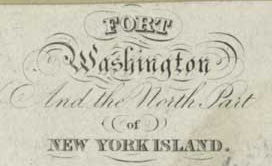
"A Plan of The Attack of FORT WASHINGTON now FORT KNYPHAUSEN and of the AMERICAN LINES on NEW YORK ISLAND By THE KINGS TROOPS on the 16th of November 1776."
|  | The American and British troop positions near Fort Washington can be clearly seen on this map. | “Fort Washington, situated between One hundred and Eighty-first and One hundred and Eighty-sixth Streets, upon thehighest eminence on the island (between ten and eleven miles from the City Hall), was a strong earth-work ofirregular form, covering, with its ravelins, several acres. It contained an inner work, a sort of citadel, within whichwas the magazine. About twenty heavy cannons were mounted upon it, besides several smaller pieces and mortars.Its chief strength consisted in its position. On the promontory below it (Jeffery’s Hook), where the Telegraph maststands (between One hundred and Seventy-sixth and One hundred and Seventy-seventh Streets), was a redoubt,intended as a covering to chevaux de frise constructed in the channel there. The banks of this redoubt, among dwarf cedars upon the rocks, are yet (1855) very prominent. Northward of Fort Washington, on the same lofty bank ofthe Hudson, between One hundred and Ninety-fifth and One hundred and Ninty-eighth Streets, was a redoubt with twoguns, which was afterward strengthened by the British and called Fort Tryon. Near the extreme point of this range,at Spyt den Dyvel Kill (Spite the Devil Creek), at Two hundred and Seventeenth Street, was a little redoubt of twoguns, called Cock Hill Fort; and across the creek, on Tetard’s Hill, was a square redoubt, with bastions, called FortIndependence. At the point where the Hudson River rail-way strikes the West Chester shore, was a small battery,and upon a hill commanding King’s Bridge from the south side, between Two hundred and Twenty-fifth and Twohundred and Twenty-sixth Streets (just above the present mill), was a redoubt. This was strengthened in 1781 by theBritish, and called Fort Prince, in honor of Prince William (afterward William the Fourth), then in New York. Theembankments of Fort Washington, and all of the works mentioned in this paragraph, are yet visible. [1850] Those of theCitadel of Fort Washington (indicated at the foot of the flag-staff) are welldefined. The military works mentioned in this note...,composed the whole of the Revolutionary fortifications upon Manhattan Island, except some breast-works atMįGowanšs Pass, between One hundred and Fifth and One hundred and Eighth Streets and the Fifth and SixthAvenues, now known as Mount St. Vincent. The embankments now seen at MįGowanšs Pass, and the squareexcavation in the rock a few rods northwest of the Roman Catholic school, were constructed in 1812. Very few of thestreets mentioned in this note have yet been opened; all of them have been surveyed and located upon the-citymaps. The streets are generally opened and graded as far as the State Arsenal, Sixty-third Street." -- PICTORIAL FIELD BOOK OF THE REVOLUTION, VOL.II., 1850, by B. Lossing
Remnants of the fort remain, along with a plaque commemorating Margaret Corbin, the first woman to "take a soldier's part" in the American Revolution.(NY Public Library, 2003)

Penny Post Card of Fort Washington Point, NY, date unknown
|